|
The report is about the excavation of the Museo ng Arkidiyosesis ng Maynila property. A permit to excavate was issued on September 9, 2011 with permission from the National Museum of the Philippines. The field assessment officially started on September 16, 2011 and it ended on October 12, 2011.
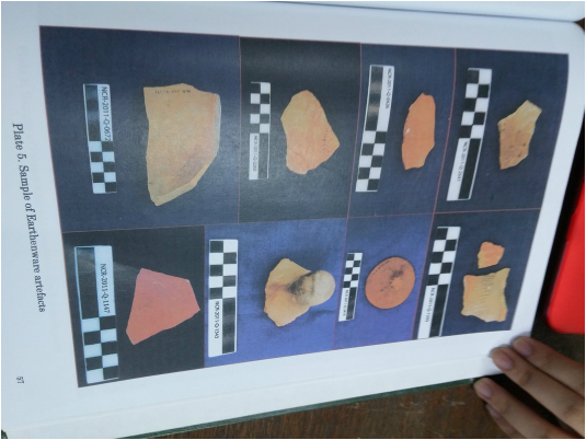
The study helped reveal new knowledge on the archaeological heritage from the pre-Intramuros period, early 1700s building phase, 19th to 20th century building phase, and several deposits from the post Second World War. This is important because the life before Intramuros was built was shown through archeology. The remains buildings in the 1700s and in the 18th to 20th century was discovered. The company recommends that the results of the study and report must be integrated into the proposal of the Archdiocese’s museum. It recommends that the newfound discoveries be included in the museum’s displays under the theme that focuses on the history of the site. Significance of the results to Manila and Philippine ArchaeologyResults of any archaeological study inside Intramuros will lead to new information that will help us in understanding our country’s history and fill in the many gaps of our knowledge about it. These knowledge gaps widen for periods before the 18th century, much more when it comes to the general pre-Intramuros period of Manila’s history.  Possible evidence of pre-Intramuros ArchaeologyPre-Intramuros layers are still yet to be revealed by any study or evidence, but the closest ever reported is a layer with dark earthenware pottery sherds exposed at the San Ignacio site by the National Museum. The result of the excavation recently performed showed possible evidences for pre-Intramuros archaeology. It is argued with the knowledge that stone, brick and tiles structure were almost absent before 1583 and that the proliferation of structure made from the materials mentioned only became standard from the late 1580s onward. The data obtained show clear absence of these materials possibly indicating that they are at the very beginning of the formation of Intramuros. Much older deposit of artefacts were also observed such as fine mid-reddish brown sand layer with earthenware pottery sherds and blue and white ceramic sherds found at Trenches 2 and 5. The reddish hue may indicate large scale oxidation process brought about by heat or fire. The twice razing to the ground of Sulayman’s Manila in the 1870s and the total fire of 1583 are possible causes of this oxidation. Another thing to note is that the water table in the property is higher than the levels of early Intramuros archaeology which may be accounted on the extensive building activity or of it connection to sea level rise/land subsidence due to extensive groundwater extraction. On the feature of Inverted JarsThe inverted stoneware jars found in Trench 3 are had similar features with the old parian district at the southern end of Intramuros, and at the PECO compound in Arlegui, Quiapo. The first well documented report of a similar feature was from 1981 Ayuntamiento site excavation wherein the jars had similar functional structures of being installed in houses for sanitary reasons or damp proofing. However, the details of the jars may have been similar in diameter (averaging 33 cm) and bottom shape but they drastically differed in height. Jars from Trench 3 were short, squat jars averaging 18.5 cm while those in Ayuntamiento were estimatedly four times taller. Construction Sequence and Style The remains of structures showed signs of modifications through time. The oldest structure in Trench 1, which is tuff slab floor together with the foundation walls of the building, go back to the 18th century. The foundation feature and wall had changes such as being plastered to one side and getting its top covered with cement mortar.
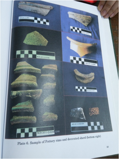
However, no intact remains of 18th century buildings were found in Trench 2, rather a 19th century building is found with a canal feature on its south side and an added flooring of tuff blocks to its north that had same level of modifications with its top just like in those in the structure at Trench 1. This may have something to do with the entryway of the building located in Trench 2. Modifications were also found in the results of Trench 3 such as a wall painted red associated with tuff slab flooring had several post holes and carved features. The last phase of modification for the 18th century building was the covering of the slab flooring with a thick layer of mortar cement. Trench 4 have a well made wall of tuff blocks and tiles covered in cement mortar and this feature was buried by construction of the 19th century building, intentionally limiting the rubble filling above the wall and covering the area with tuff blocks. Complex structures such as a finely made covered tuff block canal was also found. Similar to Trench 3 and 4, a tall wall of tuff blocks were found at Trench 5, dating to 18th century. It was covered by the rubble filling for the construction of the northern atrium of the 19th century building. Within this atrium, a later day addition was a seemingly curved brick feature. It may be consistent with the design theme noticed from the pre-World War Two photographs of the St. Paul’s hospital. Finally, the Trench 6 were exclusively dated from the 18th century even though the actual excavation space was too small to understand these structures. At the end of the assessment, most of the artifacts found were ceramic shards followed by animal bones and metals. Note that, there were no human bones recovered given that it was a battlefield for the Second World War and that it is a property of the Manila Cathedral where could have been most formal Christian burials were held. 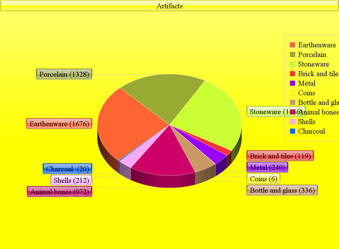 The site’s current elevation is at 8 meters above sea level which explains why the site is not prone to flooding anymore. The selection for the current sites of the trenches are backed up by by the 1713 Rojas map and the proposed development of the site. From gathered information during the early 18th Century, the property facing the Beaterio Street showed narrow buildings and an enclosed garden. 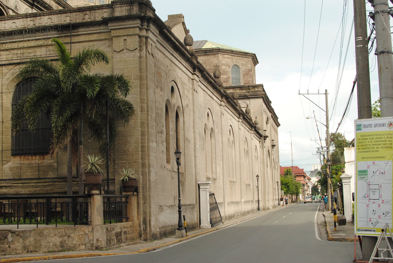 (Beaterio Street in present day-Intramuros ) During the mid 19th Century, Escuela Normal de Maestros, which is founded by the Jesuits occupied the general location but was destroyed during the 1880 earthquake and was abandoned. In 1896, a new building was constructed to make way for the San Carlos Seminary and the Cathedral Canons --- the seminary opened only for one year. 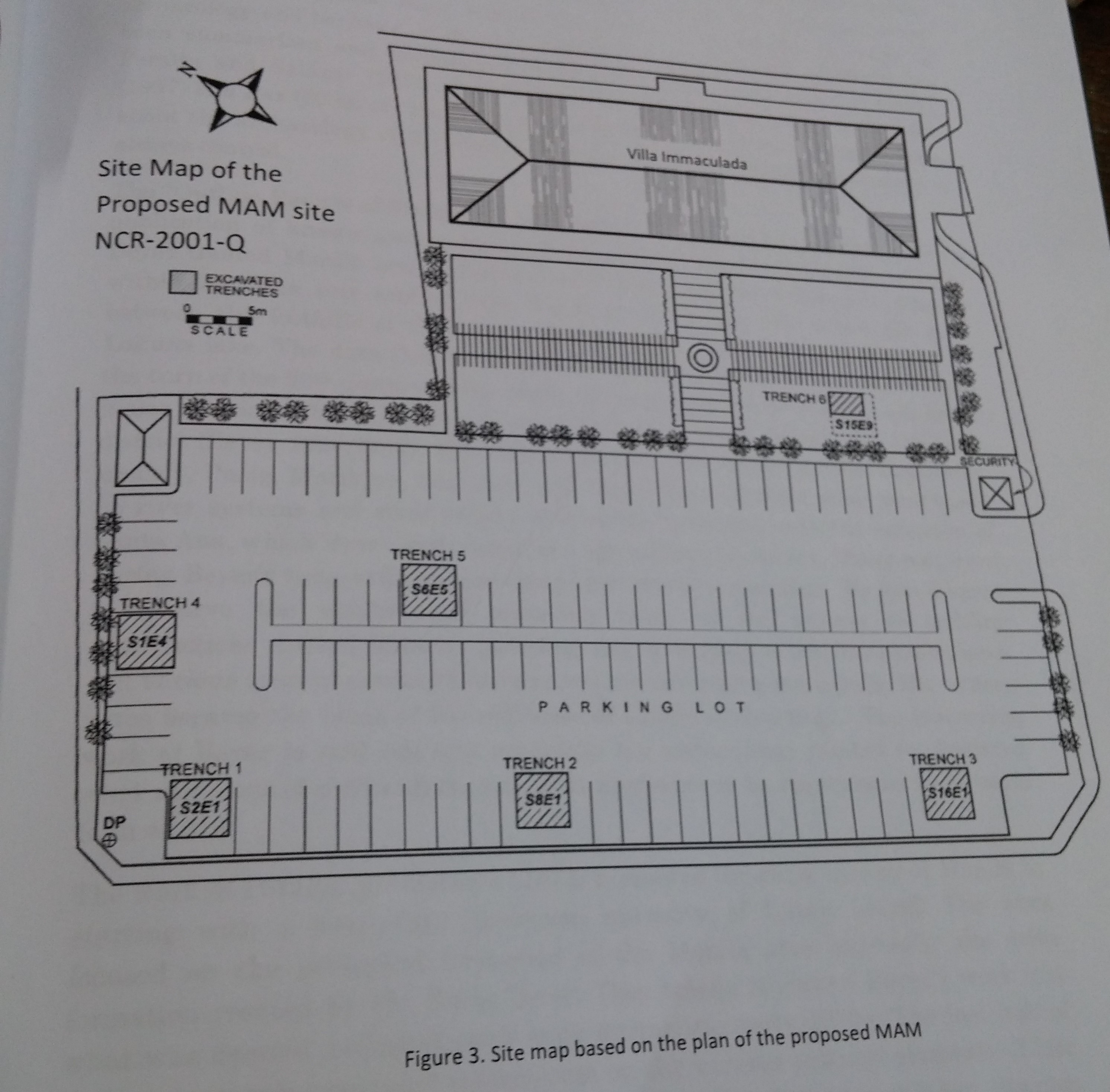 Trench 1This 4 x 4 m trench, located at grid square S2E1, was excavated to sample the archaeology at the northwestern corner of the property. This is the closest trench to the corner of Genral Luna and Beaterio streets, which could reveal building structures made at this significant street corner front property that was represented by the 1713 Rojas map as a narrow building block; in the 1815 map as a building complex with a plaza/garden in this very corner. Numerous sediments were removed from the ditch. Many artifacts such as a oxidized metal gun casing which are commonly attached to military jeeps. The remains of the foundation wall are composed of alternating layers of large blocks of volcanic tuff. Trench 2A 4 x 4 m trench (S8E1) placed at the north-south midpoint of the property of its western most boundary parallel to General Luna street. Similar to Trench 1, the car park cement surface and lattice cement decorations with an in-filling of a mid yellowish brown sandy silt sediment were placed on top of the old cement surface. Underneath the rubble, sherds were also found at the site. The current water table were exposed at c.80 and c76 203-205 cm DP. At these layers, numerous square nails, metal fragments, earthenware, and tradeware sherd were recovered. Below it is c. 90 a compact mid-greyish brown silty sand layer with numerous pottery sherds from both tradeware and earthenware. Excavation ended at the depth of 362 cm DP when it became impossible to dig any further without the walls of the trench collapsing, making further systematic study impossible given the limits of technology and amount of time Trench 3Situated at the southern part of the property (S16E1) nearest to the corner of General Luna Street and Anda Street, this 4 x 4 m trench was opened to expose the nature of archaeology at this other street block corner. At this trench, the current parking lot cement surface and cement lattice blocks did not cover a previous cement surface. Instead, it covered a light greyish brown sandy silt and a mid reddish brown clayey silt layer which contained a variety of fragments from the 19th to the 20th Century artefacts, e.g. pottery sherds, coroded metal wires and glass shards. Trench 4The 4 m x 4 m trench was located among Beaterio street axis (S1E4). The intention was to capture a glimpse of the archaeology associated with the building structures of the St. Paul’s hospital and the 1700s building depicted in the Rojas map. At the same time it was intended to go beyond Intramuros archaeology. A structure was exposed constructed from the volcanic tuff blocks and in-filled conglomerate sediments. The structure was heavily damaged across the trench but had an associated stone covered canal system. Trench 5This trench (S6E5) was opened where a massive building with two atriums is located. This 4m x 4m trench was within the calculated location of the a building’s northern atrium. It was intended for an excavation of an area with less building remains which allows for a larger area to go deeper,potentially beyond an Intramuros phase of the land. The excavation was stopped at the depth of 499 cm DP due to constant collapsing of walls because of loose sediments and waterflow. Angular sherds of dark earthenware pottery were recovered, indicating an older signal of human occupation that requires further investigation. 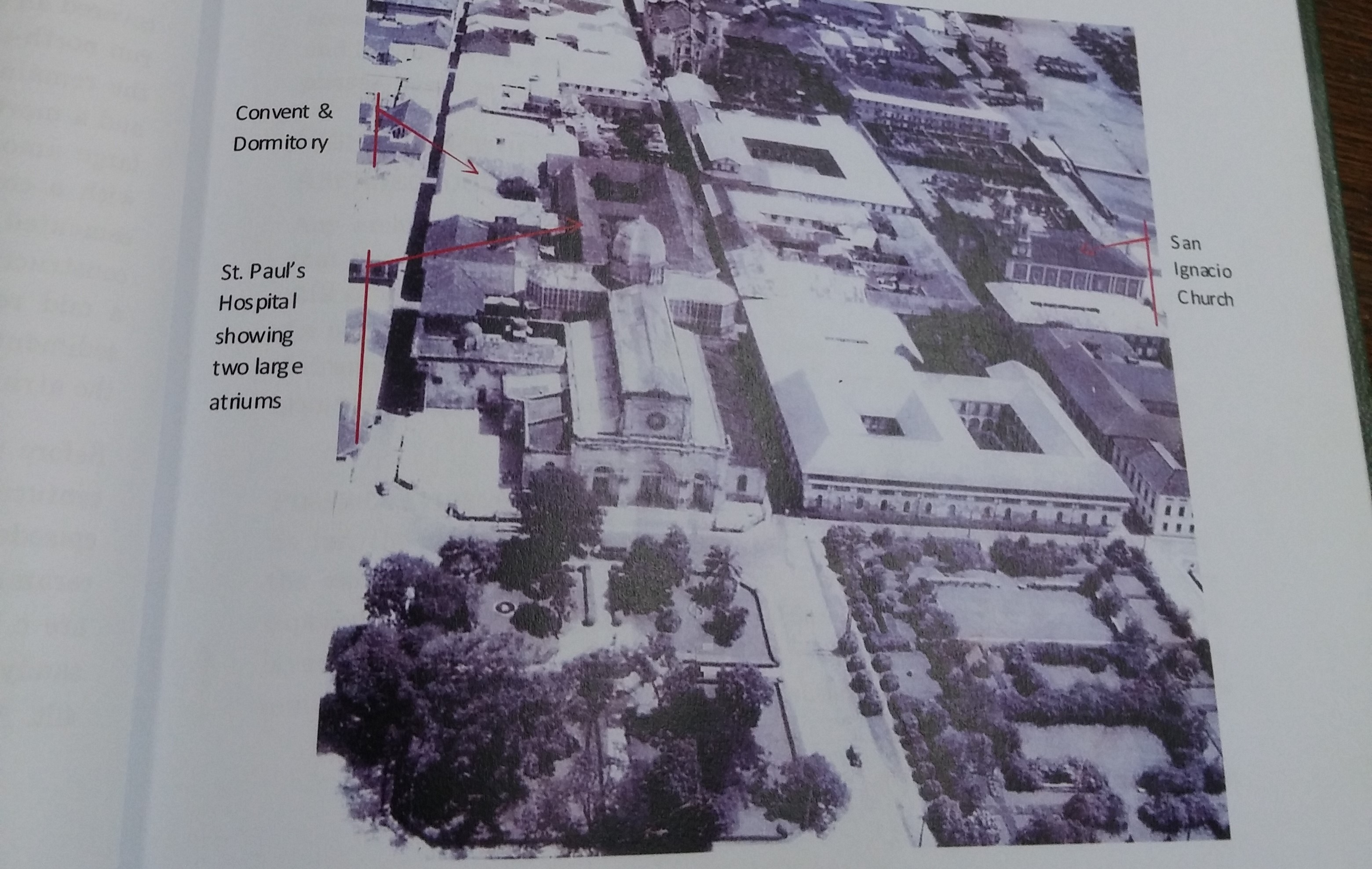 (Figure x. Aerial of Intramuros before 1945; the extent and size of the atrium of the St. Paul’s Hospital building clearly shown.) Trench 6The smallest trench on site, the Trench 6 (S15E9) was limited by the space available in the front garden of the Villa Immaculada building. The turf was carefully removed, cutting square pieces and lifting them off with the roots. The intention was to able to return the turf after the backfilling of the trench. Deposits had numerous inclusions of lime mortaring material, brick fragments, metals and ceramic sherds. A series of volcanic tuff blocks was also found as well as a flooring of volcanic tuff slabs. Upon the removal of one of the slabs was a sediment soaked in water due to high water table assisted by heavy rains during the excavation. Excavation ended with the slabs exposed at 212 cm DP
 After the permit to excavate was approved, the team, along with the National Museum and Intramuros Administration, studied any related literature about the site. They created tarpaulins that would explain what an Archaeological Impact Assessment is to any of the locals who may be wondering what was happening.
There were six trenches dug, covering five percent of the total land area. Five of the trenches were 4m x 4m while one was 2m x 3m. They used the method of removing the sediments starting with the youngest and ending with the oldest, guided by the approach of context excavation and recording system. This method meant that they would assign a context number to all sediment types, lens-type features, structures, clusters of artefacts, and dug-up features. They would then organize all of these into a matrix. The trenches were sampled with an auger and then plotted, recorded in excavation forms, plan and profile drawings, digital imaging, and excavation logbooks. All stratigraphic and depositional data were recorded in stratigraphic profiles and excavation plans, labeled by context numbers. Included with these are matrices of the site and of the trenches. All artefacts found during the excavation were accessioned using the National Museum accessioning code system and are now being stored in the National Museum off-site collection holdings at the UP ASP building. Jackhammers, metal mallets, and crowbars were used to break apart the layers of modern cement before the normal method of scraping the surface using an archaeological trowel could be done. A shovel was used when the deposit was known to be a type of filling material, or thick alluvial sediments. Water in the trenches were removed using a one horsepower and ½ Hp marine pump which allowed excavations to continue under the water table. The team also got help from metal detector hobbyists to scan for possible unexploded ordinances, which would then be dealt with by the PNP/MPD bomb squad. The metal detectors also aided in finding deposits behind the water table. Archaeological Impact Assessment for the Proposed Museo ng Arkdiyosesis ng Maynila Site, General Luna, Beaterio and Anda streets, Intramuros. (2011) HistoryThe main basis for creating this Archaeological Impact Assessment (AIA) is for the requirements set by law in the past 30 years.
AimStudy the archaeological and heritage resources by the proposed construction of a building for the “Museo ng Arkidiyosesis ng Maynila” (MAM). The location of this site is directly behind the Manila cathedral. The assessment also shows the relative impact of the proposed building construction to the archeological resources buried underneath. 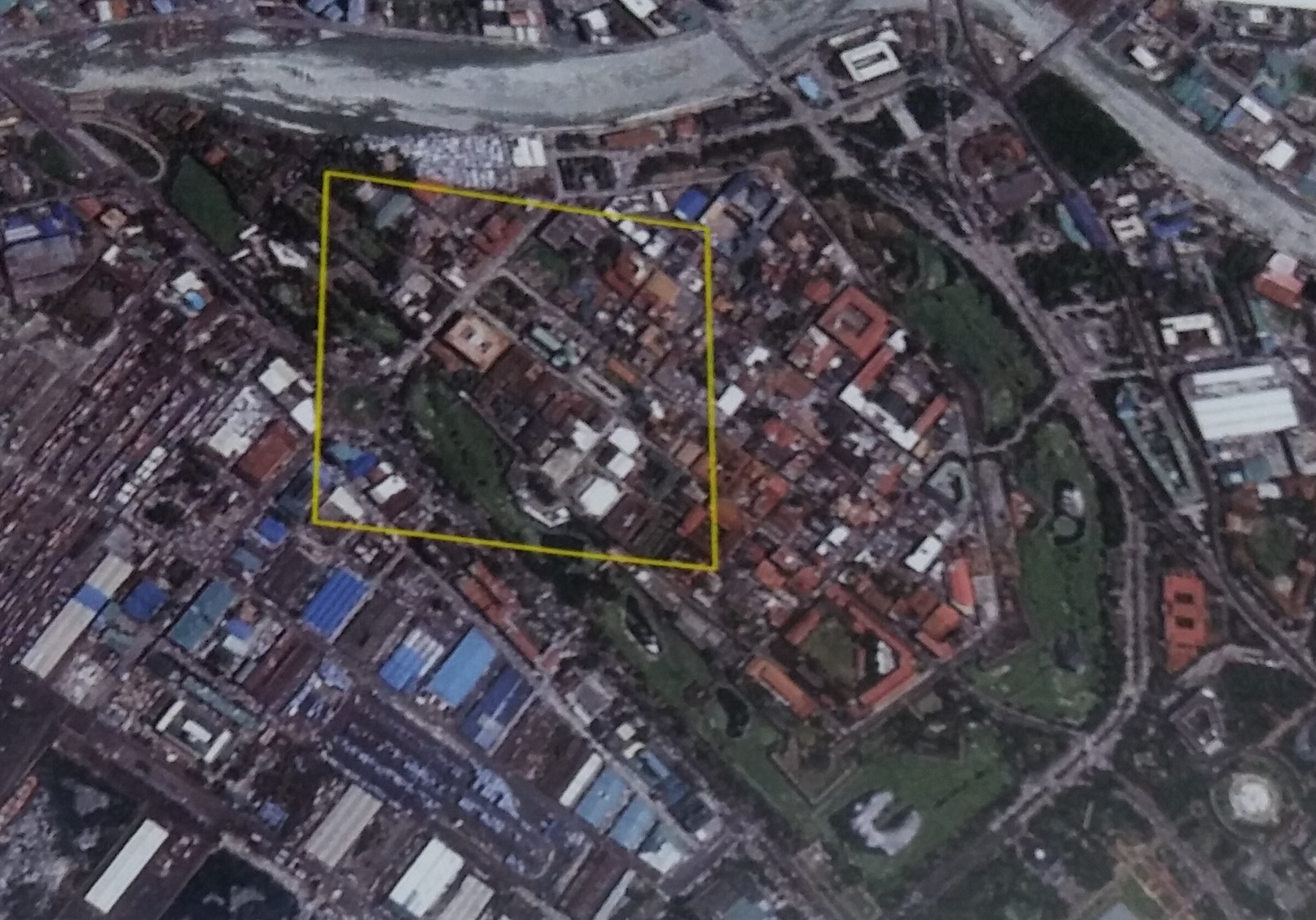 AuthorArcheological, Cultural and Environmental Consultancy Inc. (ACECI) was formed to solve the needs of industries to provide unbiased professionals in the field who are able to conduct studies and recommendations to the National museum in order to receive the necessary documentations for developers. The company was contracted by the Archdiocese of Manila to perform an AIA study in the site zone in preparation for the construction of the MAM buildings and facilities. The work took place between Sept 16 and Oct 12, 2011 and was followed by post excavation work on the data gathered.
|